Rapid Terrain Mapping from Satellite Remote Sensing

0 Reviews
0 Followers
23 Deploys

Global, Rapid, & High Precision Terrain Mapping from Satellite Remote Sensing

Page last modified
April 11 2024

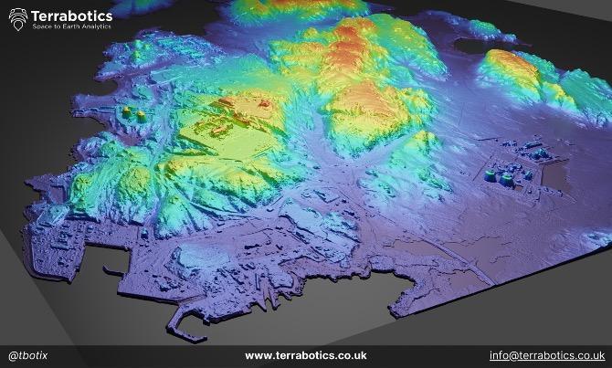
Very precise and high-resolution topographic elevation gridded data derived from remote sensing stereo satellite imagery by leveraging Terrabotics’ proprietary, best-in-class, photogrammetric sub-pixel stereo mapping engine. Delivering the highest possible vertical precision and accuracy achievable from remote sensing survey methods. These services typically include Digital elevation surface and terrain models (i.e. DSM and DTM) and map-corrected ortho-rectified satellite imagery as standard.

For the speed, cost, wide-area coverage, and safety benefits, satellite remote sensing mapping cannot be rivalled.

Rapidly, efficiently, and safely plan onshore land activities anywhere in the world:

  • Cut and fill for well pad planning
  • Routing for pipelines.
  • Site selection for facilities. 
  • Flood risk modelling
  • Landslide / landslip risk modelling
  • Earthworks monitoring
  • Encroachment monitoring


Pros & Limitations
1
Perfect for low cost, rapid, and safe reconnoissance and scouting
1
Rapid: 10 x Faster data collection, processing, analysis, and delivery than ground survey or drones.
1
Low-Cost: Less than the price of flights and people deployment to anywhere in the world.
1
High Density Point Mapping: >1 billion, 1m x 1m, terrain elevation points mapped instantly. Far more dense than
1
Remote & Safe: No HSE exposure on the ground. Remote Sensing satellites require no onsite presence.
1
Wide-area coverage versus Drones: 25 sq.km - 100,000 sq.km. Far greater than drones/uav/uas and ground survey per $
1
No Permits Required: no access permits required, map and survey anywhere in the world.
1
Global: See and map anywhere with satellite image based 3D mapping.
0
Lower horizontal and vertical accuracy versus traditional differential GPS ground survey methods.
Specification
Specification Title Specification Description
Elevation Grid Spacing & Resolutions
60cm - 1m
Elevation Accuracies
0.15cm - 0.75cm vertical
Rapid Turnaround
48 hrs to 15 days

Reviews

Get access to reviews

to your explorer or platform subscription to get access to the reviews written about this technology.

Technology Readiness Level

The Technology Readiness Level (TRL) indicates the maturity level of novel technologies. Learn more about the TRL scale used by us.

[9/9]

Development Technology demonstration Mature / Proven
Ask the supplier
 to contact this technology supplier.

Terrabotics is a full-service Earth Observation, Remote Sensing, and Geospatial data analytics company exclusively dedicated to developing and deploying solutions for the Natural Resources sectors.

Relative Business Impact

Solution Deployed By
Company Name

to your explorer or higher plan to get access to all the 23 deployment references.

Last Deployment YearTotal DeploymentsComment